Windsor, Jamaica
There is only one place that provides visitors with a comfortable base camp inside the wilderness of Cockpit Country: the Windsor Research Centre. The non-profit Centre operates from a private residence and former plantation house, Windsor Great House, which was built in the late 1700s and has been used in part as a biological research station almost continuously since the 1850s. Walks along the local roads and trails can produce nearly all of Jamaica’s endemics, most notably the Black-billed Parrot, which seems to reach its peak abundance in this corner of Cockpit Country.
Orientation
Directions
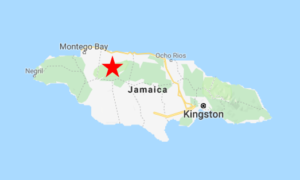
Windsor Research Centre is located deep in Cockpit Country, accessed by rough but usually passable roads, about an hour and fifteen minutes’ drive (50 km) east of Montego Bay; or forty minutes (20 km) south of Falmouth.
There are several roads into Cockpit Country that lead to Windsor. All provide visitors with ample opportunities to get lost.
From Montego Bay. There is a back road via Wakefield, but most foreign travelers are better advised to take Route A1 to Falmouth. At the Market Street exit, turn south toward Martha Brae, then take either of two routes, about equidistant, to Windsor.
Both routes are somewhat complicated, especially after dark, and way-finding GPS apps may be unreliable, so they are presented in detail in the Notes section below. The simpler route is east of the Martha Brae River, passing the Martha Brae Rafting Village. The other route is west of the river via the Good Hope Plantation.
From Ocho Rios. Take the A1 west 54 km to Duncans and turn south onto the road to Clark’s Town (Route B10). In the center of Clark’s Town, keep right to remain on the B10, heading west through Kinloss to Duanvale. In Duanvale, turn left toward Sherwood Content, then in Sherwood Content turn left again to reach Windsor.
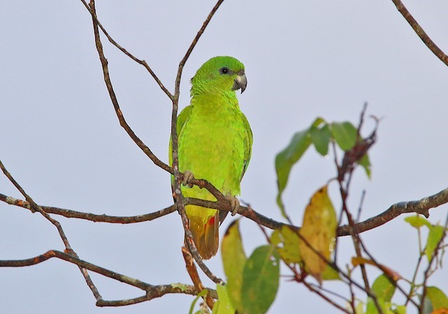
Black-billed Parrot is nowhere more abundant than at Windsor. © Tim Avery
Birdfinding
There is a small set of roads around Windsor Research Centre: a 2 km loop to the east; a short road south to Windsor Great Cave; and a 1 km road that ends at the Martha Brae River.
A morning or late afternoon stroll along these quiet roads should produce the local specialties, Black-billed and Yellow-billed Parrots, as well as most of the following: Crested Quail-Dove, Ruddy Quail-Dove, Chestnut-bellied Cuckoo, Jamaican Lizard-Cuckoo, Vervain Hummingbird, Jamaican Tody, Jamaican Parakeet, Small Jamaican Elaenia, Jamaican Pewee, Sad Flycatcher, Rufous-tailed Flycatcher, Loggerhead Kingbird, Jamaican Becard, Blue Mountain Vireo, Jamaican Vireo, Jamaican Crow, Jamaican Euphonia, Jamaican Oriole, Arrowhead Warbler, Jamaican Spindalis, Orangequit, Greater Antillean Bullfinch, and Yellow-shouldered Grassquit.
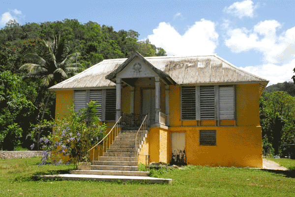
Windsor Great House, present home of Windsor Research Centre. © Dr. Raul A. Mosley

The Windsor Research Centre is located deep in Cockpit Country.
Troy Trail. Past the gatepost to Windsor Great Cave, the track splits. The right fork goes to the cave. The left fork is the beginning of the Troy Trail, a 20 km wilderness hike that goes all the way across Cockpit Country to the town of Troy.
If you plan to hike a portion of the Troy Trail, or any other local trails into the wilderness, it is important to bring water, energy snacks, sunscreen, and insect repellent, and tell someone from Windsor Research Centre when you plan to return.
A General Note of Caution. Cockpit Country is famously dangerous for hiking, mostly due to the potential for getting disoriented or falling. The terrain is irregular, uneven, and overgrown. In some places, the ground is unstable and it is possible to punch through the weak limestone into sinkholes and caverns. Apart from the Troy Trail, if you would like to explore beyond the immediate vicinity of Windsor, hire a local guide.
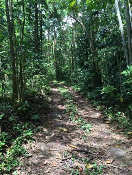
The Troy Trail at Windsor Pen. © Dr. Raul A. Mosley
Services
Accommodations
Windsor Research Centre has a rustic 3-bedroom cabin for up to six guests. A perk of staying overnight at the Centre is the opportunity to witness the nightly emergence of an estimated 100,000 bats from Windsor Great Cave.
There are numerous hotels in nearby beach towns such as Falmouth, Rio Bueno, and Runaway Bay.
Food
Windsor Research Centre serves meals by prior arrangement.
Snacks can be purchased in Sherwood Content at Miss Lilly’s Bar and Shop. Otherwise, the nearest restaurants and supermarkets are in Martha Brae and Falmouth.
Notes
Blood-Sucking Parasites. Windsor is famous for its mosquitoes, which are active and hungry all day long. It has been theorized that Usain Bolt, who was born here, owes his speed to a childhood of running from these pests. Ticks can also be a problem, so think twice before walking through any grassy patches. Insect repellent is essential.
More Directions. The roads from Falmouth to the Windsor Research Centre are rough and complicated. Starting from the Market Street exit on Route A1, turn south and follow either of the routes below.
First Option: East of the Martha Brae River, Via the Rafting Village. Follow Market Street straight into the town of Martha Brae. Turn left at the first four-way intersection. This road leaves the village and crosses a bridge over the river. At the end of the bridge, turn right toward Perth Town.
Remain on this road for 5.5 km along the meandering Martha Brae River, passing the turn-off to the Martha Brae Rafting Village, and passing through Perth Town. About 1 km past Perth Town, fork right toward Sherwood Content.
After 5.3 km this road reaches a T-junction with the Cockpit Country “Ring Road” in front of the Sherwood Content Post Office. (A left turn onto the Ring Road would take you east toward Duanvale, Kinloss, Barbecue Bottom, and Clark’s Town.) Turn right on the Ring Road. After 400 m, fork left, then drive 5 km to a T-junction. Turn left to arrive at Windsor Research Centre.
Second Option: West of the Martha Brae River, Via Good Hope Plantation. On Market Street, 100 m south of the A1 exit ramp, fork right to skirt the west side of Martha Brae. After a further 600 m fork left. Go another 1km then, soon after passing the Martha Brae Treatment Plant, fork right and stay on this road for approximately 6 km.
In a short stretch, you will (1) pass the entrance road to Good Hope Great House on your right, (2) wind around the Chukka Good Hope water park on your left, then (3) cross a bridge over the Martha Brae River. Just past this bridge, you will be at a junction of several dirt roads all leading into farmland. Pause here to get your bearings.
There should be a small pond in front of you, with roads on both sides of it. Do not take either of these roads. The road to Windsor is the next road to the left (i.e., the second road to the left of the pond). Take this road. It continues mostly straight for a little over 2km, to the base of a haystack hill, where a large dirt road joins it from the right—this is the Ring Road. (A sharp right turn here would take you west on the Ring Road to Wakefield and eventually back to Montego Bay.) Continue straight (east) on the Ring Road toward Sherwood Content.
Go straight for 100 m, then fork left to remain on the Ring Road. After another 150 m, turn right, leaving the Ring Road for a shady lane that follows the contour of a hill. This lane continues 7 km to arrive at Windsor Research Centre.